Shira Plateau Kilimanjaro: Everything You Need to Know
Estimated reading time: 23 minutes
The Shira Plateau is a vast high-altitude plateau on the western side of Mount Kilimanjaro. It formed when the ancient Shira volcano collapsed thousands of years ago, leaving behind a broad landscape of grasslands, volcanic rock formations, and unique alpine vegetation. Today, the plateau serves as one of the most scenic sections of Kilimanjaro and plays a key role in popular trekking routes such as the Lemosho Route and the Northern Circuit Route.
At an average elevation of about 3,600 meters (11,811 feet), the Shira Plateau offers spectacular views of Kibo Peak, dramatic volcanic scenery, and excellent acclimatization opportunities. Many climbers consider it one of the most beautiful areas on Africa’s highest mountain.
Whether you plan to climb Kilimanjaro or simply want to learn about its geography, the Shira Plateau deserves a place on your itinerary.
Table of contents
- Shira Plateau Kilimanjaro: Everything You Need to Know
- What Is the Shira Plateau on Mount Kilimanjaro?
- Where Is the Shira Plateau Located?
- Quick Facts About the Shira Plateau
- What Makes the Shira Plateau Unique?
- Wildlife and Plants on the Shira Plateau
- Which Kilimanjaro Routes Pass Through the Shira Plateau?
- Shira Route vs Lemosho Route
- Top Attractions on the Shira Plateau
- Can You Drive to the Shira Plateau?
- How the Shira Plateau Helps With Acclimatization
- Best Time to Visit the Shira Plateau
- FAQ
- Final Thoughts on the Shira Plateau Kilimanjaro
What Is the Shira Plateau on Mount Kilimanjaro?
The Shira Plateau is a large volcanic plateau that sits on Kilimanjaro’s western flank. It marks the remains of the ancient Shira volcano, the oldest of the three volcanic cones that formed Mount Kilimanjaro.
Millions of years ago, volcanic activity created the Shira cone. Over time, the volcano became inactive and its summit collapsed, forming the broad plateau visitors see today. Later eruptions from Kibo Volcano reshaped parts of the landscape and added new volcanic features to the area.
Today, the Shira Plateau covers approximately 62 square kilometers and ranks among the highest plateaus in the world. The plateau attracts climbers with its wide-open views, fascinating geology, and unique plant life.
Is Shira a Volcano or a Plateau?
Shira is both a volcano and a plateau.
The original Shira Volcano formed more than two million years ago and became the first volcanic cone of the Kilimanjaro massif. After the volcano stopped erupting, its crater collapsed and created the Shira Plateau.
When people refer to the Shira Plateau today, they usually mean the large flat area that stretches across Kilimanjaro’s western side. When geologists discuss Shira, they often refer to the ancient volcano that existed before the collapse.
How the Shira Plateau Formed
The Shira Plateau formed through a series of volcanic and geological events.
First, volcanic eruptions built the Shira cone. Then the volcano became extinct and lost structural support near its summit. Eventually, the crater walls collapsed and created a massive caldera-like depression. Over time, lava flows from nearby Kibo Volcano covered parts of the eastern plateau and shaped the landscape seen today.
This process created one of the most distinctive geological features on Mount Kilimanjaro.
Why the Shira Plateau Is Important
The Shira Plateau plays an important role for both climbers and scientists.
For trekkers, the plateau provides excellent acclimatization opportunities before higher-altitude sections of the mountain. The relatively gentle terrain allows hikers to gain altitude gradually while enjoying panoramic views.
For researchers, the plateau offers valuable insights into Kilimanjaro’s volcanic history, ecosystems, and geological development.
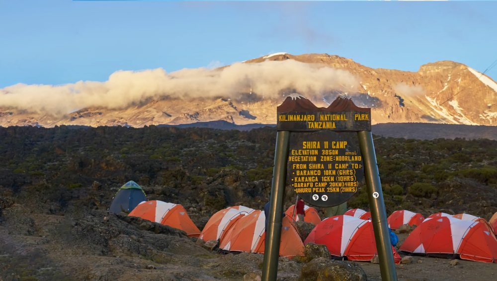
The area also contains some of Kilimanjaro’s most famous landmarks, including Shira Cathedral, Shira Ridge, and Johnsell Point.
Where Is the Shira Plateau Located?
The Shira Plateau lies on the western side of Mount Kilimanjaro in northern Tanzania. It forms part of Kilimanjaro National Park and sits between the mountain’s lower rainforest zone and the higher alpine desert region. Most climbers reach the plateau through the Lemosho Route or the Northern Circuit Route, making it one of the first major highlights of their Kilimanjaro adventure.
The plateau offers wide-open landscapes, stunning views of Kibo Peak, and some of the mountain’s most unique volcanic scenery. Its location also makes it an important acclimatization area for climbers heading toward the summit.
Shira Plateau Location on Kilimanjaro
The Shira Plateau occupies Kilimanjaro’s western flank, between the Shira Ridge and the slopes of Kibo, the mountain’s highest volcanic cone. It stretches across a vast area of open moorland and volcanic terrain, creating one of the largest high-altitude plateaus in Africa.
Travelers typically enter the plateau after passing through Londorossi Gate and ascending from the western side of the mountain. From here, the landscape opens dramatically, revealing rolling grasslands, volcanic rock formations, and distant views of Kilimanjaro’s snow-capped summit.
Because of its position, the plateau serves as a natural gateway to several of Kilimanjaro’s most scenic trekking routes.
Shira Plateau Elevation and Size
The Shira Plateau sits at an average elevation of approximately 3,600 meters (11,811 feet) above sea level. Elevations across the plateau generally range from about 3,500 meters to nearly 4,000 meters, depending on the location.
Covering roughly 62 square kilometers (24 square miles), the plateau ranks among the highest and largest volcanic plateaus in the world. Its highest point, Johnsell Point, reaches approximately 3,962 meters (13,000 feet).
The combination of high altitude and relatively gentle terrain allows climbers to acclimatize while enjoying some of the most spectacular views on Mount Kilimanjaro.
Shira Plateau Map Overview
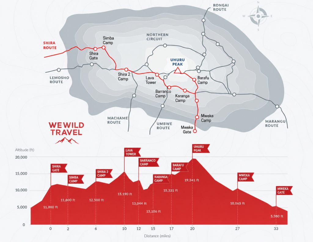
A map of the Shira Plateau shows a broad volcanic plain on Kilimanjaro’s western side. Several important landmarks stand out across the plateau, including Shira Cathedral, Shira Ridge, Johnsell Point, and the nearby Lava Tower.
The Lemosho Route crosses the plateau from west to east before continuing toward Lava Tower and Barranco Camp. The Northern Circuit Route also passes through this area before circling around the northern slopes of Kibo.
When viewed on a Kilimanjaro route map, the Shira Plateau appears as a key transition zone between the mountain’s lower moorland habitats and the harsher alpine desert environment found at higher elevations.
Quick Facts About the Shira Plateau
The Shira Plateau is one of the most remarkable features on Mount Kilimanjaro. This vast high-altitude plateau combines stunning volcanic landscapes, unique plant life, and panoramic mountain views. Many climbers consider it one of the most beautiful sections of their Kilimanjaro trek.
Elevation
The Shira Plateau sits at an average elevation of approximately 3,600 meters (11,811 feet) above sea level. Most areas of the plateau range between 3,500 and 3,900 meters (11,480-12,795 feet).
Because of its high altitude, the plateau offers climbers their first real experience of Kilimanjaro’s alpine environment. The thinner air also helps trekkers begin acclimatizing before they move to higher camps on the mountain.
Highest Point
Johnsell Point marks the highest point on the Shira Plateau. This prominent summit rises to approximately 3,962 meters (13,000 feet) above sea level.
Several other notable landmarks surround the plateau, including Shira Cathedral, Klute Peak, and Shira Ridge. These volcanic formations create dramatic scenery and offer excellent viewpoints across the western side of Mount Kilimanjaro.
Climate and Weather
The Shira Plateau experiences cool temperatures throughout the year due to its high elevation. Daytime temperatures usually range between 5°C and 15°C (41°F-59°F), while nighttime temperatures often drop below freezing.
Clouds frequently drift across the plateau, especially during the rainy seasons. On clear days, trekkers enjoy spectacular views of Kibo Peak, Mount Meru, and the surrounding plains of northern Tanzania.
Weather conditions can change quickly, so climbers should carry warm layers, waterproof clothing, and sun protection.
Routes That Cross the Plateau
Several of Kilimanjaro’s most scenic routes cross the Shira Plateau.
Lemosho Route – The most popular route through the plateau. It offers excellent acclimatization, diverse scenery, and high summit success rates.
Northern Circuit Route – Kilimanjaro’s longest route. It crosses the plateau before circling around the quieter northern slopes of the mountain.
Shira Route – This route starts at a higher elevation and reaches the plateau quickly. Fewer climbers choose this option because the rapid altitude gain provides less time for acclimatization.
Each route gives trekkers the opportunity to experience the Shira Plateau’s open landscapes, unique vegetation, and breathtaking mountain views.
What Makes the Shira Plateau Unique?
The Shira Plateau stands out as one of the most extraordinary landscapes on Mount Kilimanjaro. Unlike the mountain’s steep trails and rugged slopes, the plateau offers a vast open expanse of volcanic terrain, unique alpine vegetation, and breathtaking views. Its geological history, high elevation, and dramatic scenery make it one of the most memorable parts of any Kilimanjaro climb.
One of the Highest Plateaus in the World
The Shira Plateau ranks among the highest plateaus on Earth. At an average elevation of about 3,600 meters (11,811 feet), it rises far above the surrounding plains of northern Tanzania.
Few places in the world allow visitors to walk across such a large plateau at this altitude while enjoying relatively gentle terrain. The combination of elevation and accessibility makes the Shira Plateau a rare geographical feature and one of Kilimanjaro’s most impressive natural attractions.
For many climbers, reaching the plateau feels like stepping into a completely different world above the clouds.
Views of Kibo Peak
The Shira Plateau offers some of the best views of Kibo Peak, the highest volcanic cone on Mount Kilimanjaro and home to Uhuru Peak.
On clear mornings, trekkers can see Kibo’s massive summit dome rising above the surrounding landscape. As sunlight reaches the mountain, the glaciers and rocky slopes create a spectacular scene that photographers and climbers never forget.
The open terrain of the plateau provides unobstructed views that few other sections of Kilimanjaro can match. Many climbers consider these views a highlight of the entire trek.
Volcanic Landscapes and Open Moorlands
Ancient volcanic activity shaped every part of the Shira Plateau. Today, visitors can see lava formations, volcanic rock outcrops, and rugged ridges that reveal Kilimanjaro’s geological past.
The plateau also supports vast moorlands covered with hardy alpine vegetation. Giant groundsels, giant lobelias, and colorful wildflowers thrive in this high-altitude environment despite the cool temperatures and harsh conditions.
This combination of volcanic terrain and open moorland creates a landscape unlike any other on Mount Kilimanjaro. The scenery changes constantly throughout the day as clouds drift across the plateau and sunlight illuminates the surrounding peaks and valleys.
Wildlife and Plants on the Shira Plateau
The Shira Plateau supports a remarkable variety of plant life despite its harsh high-altitude conditions. Cool temperatures, intense sunlight, and seasonal rainfall have created a unique environment where specialized species thrive. As climbers cross the plateau, they encounter some of Kilimanjaro’s most iconic plants and experience one of Africa’s most fascinating mountain ecosystems.
Giant Lobelias
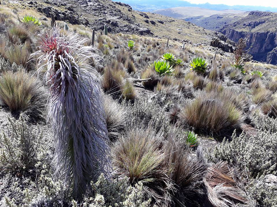
Giant lobelias rank among the most recognizable plants on the Shira Plateau. These unusual plants grow tall rosettes of thick leaves that help them survive freezing nights and strong daytime sunlight.
Some giant lobelias can reach heights of over two meters (6.5 feet), creating striking silhouettes against the open landscape. Their unique appearance often surprises climbers who do not expect to find such large plants at high altitude.
The giant lobelia has adapted perfectly to Kilimanjaro’s challenging environment, making it a symbol of the mountain’s alpine zone.
Giant Groundsels
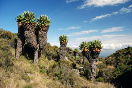
Giant groundsels are another famous plant species found on the Shira Plateau. These tree-like plants belong to the daisy family and can grow several meters tall.
Their thick trunks store water, while their dense leaf crowns protect the plants from cold temperatures. Some specimens live for decades and become important landmarks along Kilimanjaro’s trekking routes.
The giant groundsels create an almost prehistoric landscape, giving the plateau a unique character that visitors rarely find elsewhere in the world.
Afro-Alpine Ecosystem
The Shira Plateau forms part of Kilimanjaro’s Afro-alpine ecosystem, a rare habitat found only on high mountains in East Africa. This ecosystem exists between the forest zone below and the alpine desert above.
Plants and animals in this environment have developed special adaptations that help them survive dramatic temperature changes, strong ultraviolet radiation, and limited oxygen levels.
In addition to giant lobelias and groundsels, the plateau supports hardy grasses, heathers, wildflowers, insects, and various bird species. Together, these organisms create a delicate ecosystem that contributes to Kilimanjaro’s status as one of Africa’s most important natural landmarks.
For many trekkers, the unique vegetation and open landscapes of the Shira Plateau provide some of the most memorable scenery on the journey to the summit of Mount Kilimanjaro.
Which Kilimanjaro Routes Pass Through the Shira Plateau?
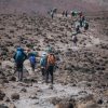
Several of Mount Kilimanjaro’s most popular routes cross the Shira Plateau. These routes give climbers the opportunity to experience the plateau’s open landscapes, unique vegetation, and spectacular views of Kibo Peak. While each route follows a different itinerary, all offer unforgettable scenery as they traverse this remarkable section of the mountain.
Lemosho Route
The Lemosho Route is the most popular route that crosses the Shira Plateau. Many climbers choose this route because it combines beautiful scenery, gradual acclimatization, and high summit success rates.
After entering Kilimanjaro National Park through Londorossi Gate, trekkers walk through rainforest and heathland before reaching the plateau. The route then continues eastward across Shira toward Lava Tower and the Southern Circuit.
The Lemosho Route typically takes 7 to 8 days, giving climbers plenty of time to adjust to the altitude while enjoying some of Kilimanjaro’s most impressive landscapes.
Northern Circuit Route
The Northern Circuit Route also passes through the Shira Plateau before circling around Kilimanjaro’s quieter northern slopes.
As the longest route on the mountain, the Northern Circuit offers excellent acclimatization and some of the highest summit success rates. After crossing the plateau, climbers continue around Kibo Peak and spend several days exploring remote sections of the mountain that receive far fewer visitors.
Trekkers who want solitude, diverse scenery, and maximum acclimatization often choose the Northern Circuit Route.
Shira Route
The Shira Route begins at a higher elevation than most Kilimanjaro routes and reaches the plateau almost immediately.
Vehicles transport climbers to the starting point at around 3,500 meters (11,480 feet), which reduces the amount of hiking required during the first day. While this route offers beautiful scenery, the rapid altitude gain provides less time for acclimatization.
For this reason, many climbers prefer the Lemosho Route, which follows a similar path but starts at a lower elevation and allows a more gradual ascent.
Route Comparison Table
| Route | Duration | Starting Elevation | Difficulty | Acclimatization | Best For |
| Lemosho Route | 7-8 Days | Low | Moderate | Excellent | First-time climbers and scenic trekking |
| Northern Circuit Route | 8-10 Days | Low | Moderate | Excellent | Maximum acclimatization and fewer crowds |
| Shira Route | 6-8 Days | High | Moderate to Challenging | Fair | Experienced trekkers comfortable with altitude |
For most climbers, the Lemosho Route offers the best overall experience on the Shira Plateau. However, the Northern Circuit provides greater solitude, while the Shira Route offers the quickest access to this spectacular high-altitude landscape.
Shira Route vs Lemosho Route
Trekkers usually spend 1 to 2 days on or around the Shira Plateau, depending on the route they choose. Shorter itineraries, such as the Shira Route, may cross the plateau in a single day, while the Lemosho and Northern Circuit routes allow more time to explore this remarkable area. Your itinerary and acclimatization schedule determine exactly how long you stay on the plateau. Extra time at this altitude helps your body adapt to thinner air, increasing your chances of a successful summit. During the journey, you’ll also have plenty of opportunities to admire the dramatic volcanic landscape, capture stunning photographs, and experience one of Kilimanjaro’s most scenic regions.
Shira Route and Lemosho Route are both western routes on Mount Kilimanjaro but they are different in safety, difficulty, and acclimatization. Shira Route starts at a very high altitude, around 3,500 meters, so climbers enter thin air immediately. Lemosho Route starts lower in the rainforest zone and climbs slowly. This makes Lemosho safer and more popular. Both routes give good views, but Lemosho gives a better trekking experience and higher summit success because the body adjusts better to altitude.
Key Differences
The main difference is altitude at the start. Shira Route starts high, so climbers feel altitude effects early. Lemosho Route starts low and climbs step by step. Shira Route skips the rainforest zone, while Lemosho passes through forest, moorland, and alpine desert. Lemosho gives more time for acclimatization, which reduces altitude sickness. Shira is shorter in lower zones but more difficult for beginners. Lemosho is longer but safer and more stable for most trekkers.
Advantages and Disadvantages
Shira Route advantages are fast access to high altitude views and fewer forest sections. But it has disadvantages like higher altitude sickness risk, poor acclimatization, and lower success rate. Lemosho Route advantages are better acclimatization, higher summit success rate, and more scenic variety. It is also safer for beginners. Its disadvantages are longer trekking days and higher cost because of more time on the mountain. Overall, Lemosho gives a better and safer climbing experience.
Which Route Is Better for Acclimatization?
Lemosho Route is better for acclimatization. It starts lower and allows the body to adjust slowly to altitude. This reduces headaches, tiredness, and altitude sickness. Shira Route starts too high, so the body struggles to adjust quickly. Because of this, Lemosho has a higher chance of reaching Uhuru Peak safely.
Top Attractions on the Shira Plateau
The Shira Plateau has several famous natural attractions that make it one of the most interesting parts of Mount Kilimanjaro. These attractions include rock formations, viewpoints, and volcanic features formed from ancient volcanic activity. Trekkers pass through or near these spots while hiking western routes like Lemosho, Shira, and Northern Circuit. Each attraction offers unique scenery, clear views of Kibo Peak, and great photography opportunities. The area is open, high-altitude, and peaceful, making it a memorable section of the climb for many hikers.
Shira Cathedral
Shira Cathedral is one of the most iconic rock formations on the Shira Plateau. It is a large volcanic structure shaped by ancient lava and erosion over time. Trekkers often stop here because it offers wide views of the surrounding plateau and Kibo Peak. The area feels open and quiet, with strong winds and thin air due to high altitude. It is also used as a resting point during acclimatization hikes. Its massive cliffs and distinctive rock formations make Shira Cathedral one of the most photographed landmarks on this side of Mount Kilimanjaro.
Shira Ridge
Shira Ridge is a long elevated section of the plateau that offers clear panoramic views of the landscape. From the ridge, trekkers can see open moorlands, volcanic rock formations, and distant views of the summit area. The ridge is important for acclimatization because it keeps climbers active at high altitude. The area is usually windy and cold, but the visibility is often very good on clear days. Many trekking routes pass near or along Shira Ridge, making it a natural viewpoint where climbers can rest and take photos.
Johnsell Point
Johnsell Point is a less crowded viewpoint on the Shira Plateau. It is used as a resting or observation spot during trekking. From this point, climbers can see wide open plains and parts of the mountain landscape. It is not as famous as other landmarks, but it is still valuable for its calm environment and scenic views. Trekkers often stop here to adjust to altitude and enjoy the silence of the plateau. The location gives a clear feeling of isolation and high-altitude wilderness.
Lava Tower
Lava Tower is a major volcanic rock formation near the Shira Plateau area and is one of the key acclimatization points on Kilimanjaro. It was formed from solidified lava from ancient volcanic activity. Trekkers usually pass this area on routes like Lemosho and Northern Circuit. The climb to Lava Tower helps the body adjust to higher altitude before descending for sleep, which improves acclimatization. The landscape around Lava Tower is rocky, dry, and very exposed, showing the harsh alpine environment of Kilimanjaro.
Can You Drive to the Shira Plateau?
Yes, you can drive close to the Shira Plateau, but you cannot drive across it. Vehicles can reach a high starting point on the western side of Mount Kilimanjaro through Londorossi Gate. From there, trekkers continue on foot. This makes the Shira Route different from other routes because it allows a vehicle-supported start at high altitude. However, the real experience of the plateau still requires hiking. The drive mainly helps reduce walking distance at the beginning, but climbers still need to adapt to high altitude conditions immediately after starting the trek.
Access via Londorossi Gate
Londorossi Gate is the main access point used to reach the Shira Plateau area from the western side of Kilimanjaro. Vehicles drive from Moshi or Arusha through forest roads until they reach a drop-off point above the rainforest zone. This route is rough and depends on weather conditions, especially during rainy seasons. From Londorossi Gate, trekkers register and then continue deeper into the mountain area. This gate is important because it allows access to higher starting points compared to other Kilimanjaro routes.
Vehicle Access Explained
Vehicles can only go part of the way to the Shira Plateau. They stop at a designated drop-off point where the road ends and trekking begins. The rest of the journey must be done on foot because the terrain becomes too steep, rocky, and protected for vehicles. This is also done to protect the environment and maintain the natural condition of the mountain. The vehicle access mainly helps trekkers start at higher altitude, which shortens the first trekking section but increases immediate exposure to thin air.
What to Expect After Arrival
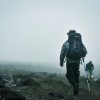
After arriving at the drop-off point, trekkers immediately enter a high-altitude environment. The air is cooler, thinner, and more open compared to the forest zone below. The landscape becomes wide and volcanic, with few trees and more grassland and rock formations. Climbers often feel the altitude quickly because of the elevation. The trekking begins across open moorland, and the scenery becomes very expansive with views of Kibo Peak on clear days. It is a quiet and remote area with strong winds and changing weather conditions.
How the Shira Plateau Helps With Acclimatization
The Shira Plateau plays an important role in helping climbers adjust to high altitude on Mount Kilimanjaro. It sits at a high elevation where oxygen levels are lower, so the body starts adapting early. This area is often used in western routes like Lemosho and Northern Circuit to improve acclimatization before moving to higher camps. Spending time on the plateau helps reduce altitude sickness because climbers experience high altitude conditions while still trekking at a steady pace. The open landscape also allows gradual exposure to changing oxygen levels, which helps the body prepare for the summit push.
Altitude Benefits
The main benefit of the Shira Plateau is its high altitude. At around 3,500 meters, the air is thinner and contains less oxygen compared to lower parts of the mountain. When climbers spend time here, their bodies start producing more red blood cells to carry oxygen more efficiently. This natural adjustment helps reduce symptoms of altitude sickness such as headaches, nausea, and fatigue. Because climbers are already exposed to high altitude early in the trek, their bodies become stronger and more prepared for higher camps later on Kilimanjaro.
Climb High, Sleep Low Principle
The “climb high, sleep low” principle is commonly used around the Shira Plateau area. Climbers hike to higher elevations during the day, such as ridges or nearby peaks, and then descend to sleep at a lower camp. This method helps the body adjust to altitude without putting too much stress on it. On the Shira Plateau, this process works well because the terrain allows easy movement between different elevations. It improves oxygen efficiency and gives the body time to recover at night, which is very important for long climbs like Kilimanjaro.
Impact on Summit Success Rates
The Shira Plateau improves summit success rates because it supports early acclimatization. Climbers who spend time adjusting at this altitude are less likely to suffer from severe altitude sickness later on the mountain. This leads to better energy levels, stronger performance, and more stable climbing progress. Routes that pass through the Shira Plateau, especially Lemosho and Northern Circuit, usually have higher success rates compared to shorter or steeper routes. Proper acclimatization here increases the chance of reaching Uhuru Peak safely and comfortably.
Best Time to Visit the Shira Plateau
The best time to visit the Shira Plateau is during the dry seasons when the weather is more stable and the trails are easier to walk. During these months, the sky is usually clear, visibility is good, and trekkers get better views of Kibo Peak and the surrounding landscapes. The plateau is high and exposed, so weather changes quickly, but dry seasons reduce rain, mud, and cloud cover. This makes trekking safer and more comfortable, especially for climbers who want better photography and easier hiking conditions. The main trekking seasons on Kilimanjaro also match these periods, so more guided climbs happen during this time.
January to March
January to March is a good time to visit the Shira Plateau. The weather is generally clear, and the mountain is less crowded compared to peak season. Temperatures are cold, especially at night and early morning, but daytime conditions are usually stable for trekking. This period also offers good visibility of the landscape, including wide views of the plateau and Kibo Peak. However, some light rain can still occur in early March, so trekkers should be prepared for mixed conditions. Overall, this season is suitable for climbers who prefer fewer crowds and calm trekking routes.
June to October
June to October is the most popular and best time to visit the Shira Plateau. This is the main dry season in Tanzania, so the weather is more stable and predictable. Trails are dry, skies are often clear, and visibility is excellent. This makes it easier to enjoy the open landscapes of the plateau and take clear photos. Temperatures are cold but manageable for most trekkers. Because this is peak season, more climbers are on the mountain, so routes can feel busier. However, it is the safest and most reliable time for trekking Kilimanjaro.
Rainy Seasons
The rainy seasons are from April to May and again in November. During this time, the Shira Plateau becomes wetter, colder, and more difficult to trek. Clouds often cover the mountain, reducing visibility and blocking views of Kibo Peak. Trails can become muddy and slippery, making hiking more challenging. Heavy rain is not constant, but conditions are less stable compared to dry seasons. Fewer trekkers choose this time, so the mountain feels quiet and less crowded. However, it is not the best time for beginners or first-time Kilimanjaro climbers due to weather difficulty.
FAQ
The Shira Plateau is one of the most interesting parts of Mount Kilimanjaro, and many trekkers ask questions about its height, difficulty, routes, and trekking time. These questions usually come from climbers who want to understand what to expect before choosing a route. The plateau sits at high altitude and is part of several major Kilimanjaro routes, so it plays an important role in acclimatization and scenery. Below are the most common questions with simple answers to help you understand the Shira Plateau better before your climb.
The Shira Plateau is about 3,500 meters above sea level. This makes it one of the highest plateaus on Mount Kilimanjaro. At this altitude, the air is thinner and oxygen levels are lower compared to the lower forest zones. Climbers often feel the change in breathing and energy when they reach this level. Because of the height, the plateau is an important acclimatization area for western routes like Lemosho and Northern Circuit. The high elevation also creates wide views of the mountain landscape and Kibo Peak on clear days.
Yes, beginners can visit the Shira Plateau, but only as part of a guided Kilimanjaro trek. The plateau is not a tourist site you can visit independently; it is inside the mountain climbing routes. Beginners usually experience it through routes like Lemosho, which are safer because they allow gradual acclimatization. However, the altitude is high, so beginners must be prepared for thin air, cold temperatures, and physical effort. With proper guidance, pacing, and acclimatization, beginners can safely experience the Shira Plateau during their climb.
The Northern Circuit Route offers the best views of the Shira Plateau because it spends more time crossing the area. Trekkers get wide panoramic views of open moorlands, volcanic formations, and Kibo Peak. The Lemosho Route also offers excellent views and is very popular for scenic trekking. Both routes pass through beautiful parts of the plateau, but Northern Circuit gives the longest and most detailed experience. Shira Route also offers direct views, but it is shorter and less commonly used today. Overall, Northern Circuit provides the most complete visual experience.
Trekkers usually spend 1 to 2 days on or around the Shira Plateau depending on the route. Shorter routes like Shira may pass through quickly in one day, while Lemosho and Northern Circuit spend more time crossing and exploring the area. The duration depends on the trekking schedule and acclimatization plan. Spending more time on the plateau helps the body adjust better to altitude and improves summit success chances. Longer exposure also allows trekkers to enjoy the scenery, take photos, and experience the unique volcanic landscape of this part of Kilimanjaro.
Final Thoughts on the Shira Plateau Kilimanjaro
The Shira Plateau is one of the most important and scenic areas on Mount Kilimanjaro. It offers wide open landscapes, strong volcanic features, and clear views of Kibo Peak. It also plays a key role in acclimatization because of its high altitude. Trekkers passing through this area experience one of the most unique sections of the mountain, especially on western routes like Lemosho and Northern Circuit. The plateau shows both the beauty and the challenge of Kilimanjaro, combining high elevation with dramatic natural scenery. For most climbers, it becomes a memorable highlight of the entire journey to Uhuru Peak.